When the Stars and Stripes flew over Hastings


The ‘America Ground’ as it became known was land left when the sea receded and is shown, unnamed, on the earliest maps that appeared in the mid 18th century.
The area extended from the sea to what is now Cambridge Road and White Rock to the Priory Stream that formed the western boundary of Hastings and its powers.
Advertisement
Hide AdAdvertisement
Hide AdUp until around 1800 there was little occupation apart from two rope-walks, a shipyard and a few other trades connected with the sea and the servicing of its neighbour, Hastings.
The location was also seen as a potential site for a harbour, and in 1806 a survey was carried out by Sir John Rennie, the civil engineer, but the plan came to nothing. As the population of the waste ground grew Hastings Corporation cast covetous eyes on the area and its 1,000 or so inhabitants who claimed they owed no allegiance and therefore paid no taxes to the corporation.
The population of Hastings itself had doubled in the 20 years from 3,318 in 1801 and had expanded to 14,016 fifty years later so that the Old Town Valley was outgrown with development spreading westwards, past George Street, (once known as ‘The Suburbs’) to the fine houses of the 1820’s, built where the Castle Rocks were cut away to form Pelham Place, Pelham Crescent, Breeds Place and Castle Street as far as the now-gone Kentish Buildings just east of the Priory Bridge.
Meanwhile, west of the Priory Bridge the increasing population of working people had taken advantage of the ‘No Man’s Land’ to build their houses, shanties and warehouses, for which they paid no rent or taxes and there were provocative suggestions of lawlessness prompting the Corporation to approach the Government to take some steps to get rid of the nuisance. The inhabitants, to show their independence, hoisted the American flag, thus earning the name for their territory of the ‘America Ground’.
Advertisement
Hide AdAdvertisement
Hide AdContrary to popular belief there was a dispute over the ownership of the land; on the one hand, Lord Chichester as holder to the Castle lands, laid claim to it under a grant made to his family under a charter of James 1st and on the other Hastings Corporation claimed it under their Charter from Elizabeth 1st. Another claimant duly appeared on the scene, Lord Cornwallis, holder of the Priory Estate and later, a fourth claimant was invited, Battle Abbey Estates (Sir Godfrey Webster).
The enquiry was held at the George Inn in Battle in 1828 to settle the dispute, sufficiently far away to deter the ‘Americans’ from attending. The outcome was that the Crown, judge and jury in the case, awarded itself the land and issued seven year leases to the inhabitants, after which the whole town was to be cleared away.
The dwellings seem to have been brick and stone with the timber buildings appearing to be generally for workshops and animal containment and a total of 199 premises with 99 prospective lessees were are noted. The Corporation settled their boundary, (the Priory Stream) and the high ground above Claremont was claimed by Lord Cornwallis as showing the boundary to his property, and the land between the two boundaries was appropriated by the Government.
By 1835 the America Ground had been cleared with the inhabitants dispersed elsewhere in the town, particularly Halton, and the new town of St. Leonards, to the west of the Priory Valley and established by Alfred Burton in 1828 and the America Ground, so bitterly fought over in the 1820s, was a derelict waste throughout the 1840s.
Advertisement
Hide AdAdvertisement
Hide AdThe headland known as the White Rock, which had always protected the valley from the force of the sea, was removed in 1834 with the unfortunate result that the valley to the east was left unprotected and two years later there was heavy flooding. By 1838 part of the Priory Marshes was drained by running an iron culvert from the bridge to the sea and a pedestal with three lamps was placed on the site of the old bridge which remained until the Albert Memorial was built in 1862-63 on the same spot.
It is worth noting the final smug comments of the Commissioners, after praising themselves on the generosity in the granting of seven year leases, they observe: “while we shall have succeeded in acquiring on the behalf of the Crown, the disputed possession, at the end of seven years, a very valuable estate, from which no profit or income has hitherto been derived by the Crown.”
All illustrations throughout this series are from Ion Castro’s own collection and he can make available copies of many of the historic images used in this series. There’s more local history on Ion’s website, www.historichastings.co.uk and more information about the America Ground on www.1066.net/america
Captions:
America Ground – Before.
One of a pair of images showing the view from the Coastguard Cottages at Prospect Place on the White Rock showing the unbuilt America Ground. The Priory Bridge would be just below left of centre. York Buildings and The York Hotel as well as Wellington Square etc. are in place
America Ground – After.
Advertisement
Hide AdAdvertisement
Hide AdThe second of the pair of images and the Buildings on Robertson Street are now in place.
Carlisle Parade.
1863 as photographed by Francis Frith for his book ‘The Gossiping Photographer at Hastings’ Robertson Terrace is now complete and on the left the square tower of the original Congregational Church tower can be seen behind Messrs. Lancaster’s shop which, like the church, also had an entrance in Cambridge Road. Robertson Street was originally planned as private houses but, by 1860 many had already been converted into shops, the ‘Regent Street of Hastings’
Derelict Lands.
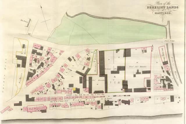
This map accompanied the seventh report of His Majesty’s Commissioners of Woods Forests and Land Revenues 1830 and clearly shows the extent of occupation. The Priory Bridge can be seen on the upper right of the site.
From the Priory Bridge.
A view into the America Ground, the large building is probably Deudney’s White Rock Brewery built below the cliffs and redeveloped in the 1880’s as the Palace Hotel. Notice the lamps marking the site of the Priory Bridge, these would later be replaced with the Albert Memorial.
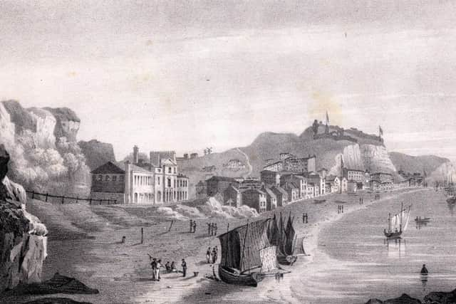
Hastings from the White Rock.
Advertisement
Hide AdAdvertisement
Hide AdA lithograph by Thomas Ross who had a very keen interest in the town, he had been Mayor five times between 1856 and 1872, Ross was an amateur archaeologist, JP, Chairman of Guardians, drawing master, author and publisher operating from 6 Castle Street and later Claremont. The White Rock Brewery can be seen on the left and Pelham Crescent in the distance.
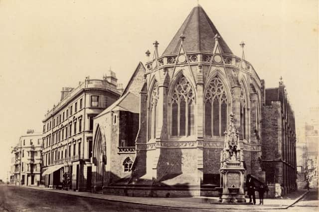
Holy Trinity.
1863, photographed by Francis Frith for his book ‘The Gossiping Photographer at Hastings’ looks almost as today but closer examination shown bottom of the cliff where the Brassey institute and Parsons Printing Works will be built and an extension to the church has been added behind the Countess Waldegrave Fountain.
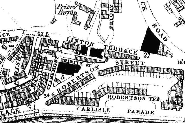
Lang’s Map 1859.
Lang surveyed had the town by 1859 and this portion of the map shows the America Ground almost complete, but notice that Roberson Terrace is still unfinished and Linton Terrace is now the lower end of Cambridge Road.
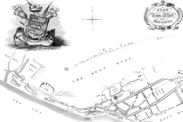
Moss Map.
Moss’ map of 1824 to accompany his guide shows the Hastings boundary at the Priory Water with the Priory Bridge below the fork in the stream.