This is what Hastings could look like in 2100


That is according to an interactive map which shows what the world is projected to look like in the year 2100, after the polar ice caps melt and sea levels rise.
Surging Seas, the project which has created the map, said: “Without big cuts in climate pollution, an unstable Antarctica could double previous sea level projections.”
Advertisement
Hide AdAdvertisement
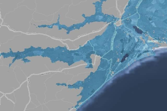
Hide AdAccording to the map, huge ares of Rye, Winchelsea and Camber would be completely underwater in 81 years.
The A259 would be totally flooded from Winchelsea all the way through to Hythe, in Kent.
The picture is not much better further west.
According to the map, much of west St Leonards and Bexhill would be underwater, with the A259 at Bulverhythe totally flooded.
Moving further afield, much of the area west of Bexhill would also be destroyed, according to Surging Seas.
Advertisement
Hide AdAdvertisement
Hide AdPevensey and Westham are practically all underwater in the scenario, and parts of Hailsham and Polegate would not escape the sea.
It’s a bleak outlook for Sussex – and the rest of the country... and world.
Surging Seas has been developed by Climate Central, a nonprofit science and news organisation which researches climate change.
It says global warming has raised the global sea level about eight inches since 1880, and the rate of rise is accelerating – increasing the odds of damaging floods from storm surges.
To view the interactive map, visit: sealevel.climatecentral.org/maps