End of the road at Rock-a-Nore where land meets sea


He writes. Rock-a-Nore is the uniquely named eastern end of Hastings where the road along the seafront and under the East Cliff ends.
The origin of the name is lost in the mists of time but J.M Baines, former curator of Hastings Museum and Hastings History Guru wrote in ‘Historic Hastings’ “In 1581 the enquiry into the Chantry Lands noted a shop or small building belonging to one William Creassye, ‘Iyinge to the Mayne Rocke against the north’
Advertisement
Hide AdAdvertisement
Hide AdThis description became shortened into the present form and was officially so called in 1859. Rock-a-Nore has also been noted for its caves which were for a time inhabited by the Butler family. In 1843 Ross called them:” a family Robinson Crusoe, for as such we may fairly designate them, and fear not that all who visit them will be gratified, and seeing their mode. The caves continued to be occupied intermittently until sealed in the 1960’s by the council to prevent their use by ‘beatniks’
Hastings was blessed with a large number of very competent photographers but the town also attracted others such as the photographer William Russell Sedgefield, (1826 -1902) who was born in Devizes, Wiltshire, and by the age of 18 he had become an engraver for Punch but he wanted to follow a career in photography and by 1842, when only 16, had applied to Henry Talbot for a calotype licence but was shocked to receive a demand for £20 from Talbot’s solicitor.
Rather than pay, he decided on the risky course of continuing without a licence. He moved to London and by 1854 Samuel Highley, a London publisher, was offering for sale Sedgfield’s photographs and especially his folios entitled ‘Photographic Delineations of the Scenery, Architecture, and Antiquities of Great Britain and Ireland’. It was issued in four parts, the first two with photographs of East Anglian architecture. The albumen prints, measuring about 25 x 20 cm (10 x 8 inches) and were laid down on card.
Sedgefield’s stereoscopic photographs from the mid 1850s to the early 1860s were published mainly by Alfred W. Bennet, of London, and the London Stereoscopic Company. ‘Sedgfield’s English Scenery’ and ‘Sedgfield’s Welsh Scenery’ series, were issued between 1855 and 1856 and ran to a series of over 800. Sedgfield married Elizabeth Knight in 1857 and they had 2 daughters. Throughout his long career he contributed to the photographic journals and his photographs were used to illustrate a number of books.
Advertisement
Hide AdAdvertisement
Hide AdAnother well known ‘foreign’ photographer was Frederick Nutt Broderick, born in Kennington, London in 1854, the son of an engraver and printer. His family moved to Ryde in the Isle of Wight where Frederick Nutt Broderick was one of Ryde’s most successful photographers, active from about 1878 to his death in 1913. Already well - known for his photographic views he soon began to produce postcards as well, often from the same plates. In fact, it was possible to buy one of his views as a postcard, a larger print on card ready to frame, or even one on glass ready to hang on the wall, depending on your budget.
Many of these were entitled ‘The Aurora Series’ after his daughter, after whom he also named his house in West Street. With an eye to commerce he went out all over the Island photographing events such as the hunt, carnivals or even wrecks, such as the ‘Gladiator’. All these images were produced very quickly, usually dated, to sell while the event was still fresh and hoping someone would spot themselves in the background crowd and purchase multiple copies to post off to friends. As well as local scenes of the Isle of Wight Broderick travelled to the mainland, particularly Hastings, and even abroad
All illustrations throughout this series are from Ion Castro’s own collection and he can make available copies of many of the historic images used in this series. There’s more local history on Ion’s website, www.historichastings.co.uk or contact him - [email protected].
Captions:
East Hill and Fairlight Cliffs. An uncredited aerial photograph, probably from the 1950’s showing Rock-a-Nore below the East Cliff and showing the Fishermen’s winch huts in a row and coaches parked lower left.
Fishermens Museum.
Advertisement
Hide AdAdvertisement
Hide AdAn uncredited postcard from the late 1950’s. The Museum opened in 1956 in the former Fishermen’s Church of St Nicholas. This was a mission chapel which served the fishing community from 1854 until the building was requisitioned by the military authorities to become a wartime store. The building is listed Grade II by English Heritage for its architectural and historical importance. The Museum is managed by the Old Hastings Preservation Society who rescued the building and lease it from Hastings Borough Council. In 2001 funding was raised to build an extension which provides visitors with extra exhibition space and an audio visual presentation. It’s name is now almost synonymous with Rock-a-Nore.
Fishing Village Hastings.
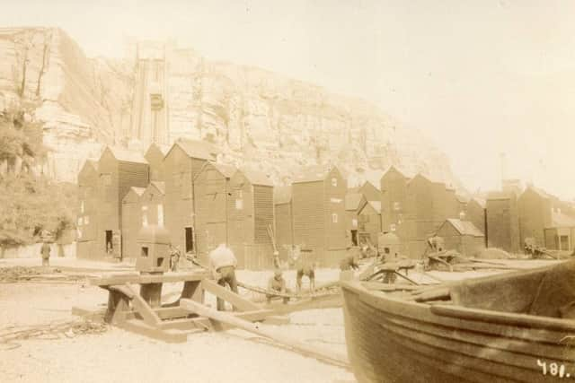
An uncredited postcard from the 1930’s with Rock-a-Nore nestling below the East Cliff - notice the East Hill Lift. On the beach are the horse capstans used for pulling up the fishing boats with their tangle of cables and the Fishermen’s Church of St.Nicholas can be seen surrounded by net shops and beyond it the castellated Drill Hall.
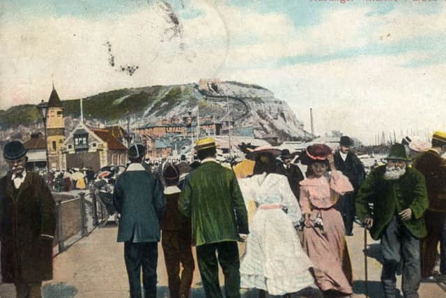
Marine Parade on a windy day.
Posted in September 1907, Rock-a-Nore is the eastern continuation of Marine Parade and the original Lifeboat House can be seen on the left and the East Hill Lift, opened 1902, in the centre and the dust destructor chimney to its right, the dust destructor fuelled the pump that lifted the water ballast to the top of the lift where it was stored in the twin towers that still exist. The lift is now operated electrically.
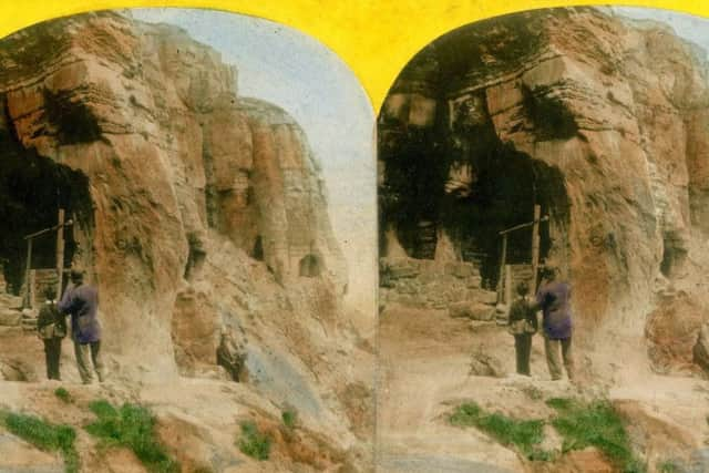
Robinson Crusoe’s Caves.
Captured by an uncredited photographer in the 1870’s this hand tinted stereo card shows the caves above Rock-a-Nore which were occupied by a family called Butler, In 1843 Thomas Ross, one time Mayor of Hastings and local historian Ross called them:” a family Robinson Crusoe, for as such we may fairly designate them, and fear not that all who visit them will be gratified, and seeing their mode”
Advertisement
Hide AdAdvertisement
Hide AdRock-a-Nore. An uncredited Stereo pair from the 1870’s showing the ephemera of a working beach below the East Cliff
Sedgefield’s English Scenery.
The picturesque nature of Hastings’ Old town was widely recognised attracting photographers such as Sedgefield from afar. The image shows the Crusoe caves in the 1870s above fishermen’s sheds and the jumble of fallen rocks suggesting that the East Cliff was not as stable as it is today.
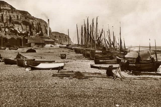
The Beach Old Hastings.
This postcard published by Palace Book Shop, 37 White Rock, Hastings was posted in 1935 and the writer, in St Leonards says “Mother and I went on the trolley bus to the Old Town of Hastings, we should have liked to have had more time there but father could not come so we did not stay long. It is very quaint here and quite different from the new part of Hastings. The image shows traditional Hastings fishing craft drawn up on the beach with Rock-a-Nore on the left. The local fishing boat registration of RX can be seen on all the boats and a fisherman sits mending his nets. The chimney of the ‘dust destructor’ can be seen gently smoking in the left centre of the picture.
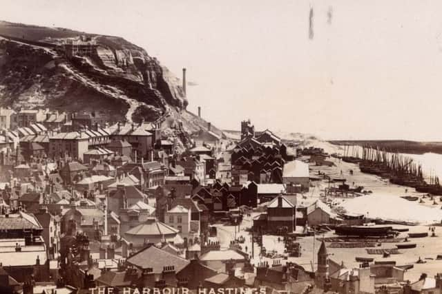
The Harbour Hastings from the West Hill.
A Broderick photographic postcard posted in July 1906 and showing the area generally known as Rock-a-Nore with the dust Destructor Chimney in the centre and the Net Shops surrounding the Fishermen’s Church and the tower of the lifeboat station centre foreground.
The Old Town Hastings.
Advertisement
Hide AdAdvertisement
Hide AdA photographic postcard from Broderick’s ‘Aurora Series’ showing the horse capstans used for pulling the fishing boats up the beach and the cluster of net shops just below the East Hill Lift, the steepest funicular railway in the country and worked on water ballast in the tank below the descending car making it heavy enough to pull the other car to the top of he track. Water was pumped into storage tanks at the upper station by a pump fuelled by the dust destructor.
Benefit from an ongoing discount on your Hastings Observer by joining our voucher membership scheme. Once you’ve subscribed we’ll send you dated vouchers which can be exchanged for your paper at any news outlet. To save money on your Observer simply click here (www.localsubsplus.co.uk)