How a London architect created St Leonards


He writes: St. Leonards didn’t exist until London architect James Burton bought what had been farmland to the west of Hastings from the Eversfield estate and built his new town with the iconic St.Leonards Arch across the seafront marking its eastern boundary, just west of the bottom of today’s London Road.
This arch was covertly demolished during the course of one night of 23rd January 1895 by Hastings Council ‘for road widening’, despite major public opposition.
Advertisement
Hide AdAdvertisement
Hide AdThe postal boundary between Hastings and St.Leonards ran inland from Hastings Pier and this has often been a source of confusion when boundaries are discussed. The new town of St.Leonards was run by a board of commissioners until 1872 when it merged with its neighbour Hastings which had outgrown its origins in the old town valley and was creeping westwards eventually meeting St Leonards and producing a combined population of nearly 50,000 in 1881.
For the century from St.Leonards’ foundation in 1828 the seafront area evolved slowly with the dramatic changes influenced by none other than the ‘Concrete King’ Sidney Little who rebuilt the entire seafront from Pelham Crescent in the east, via the White Rock Baths (opened 1931) under the promenade east of Hastings Pier and his masterpiece ‘Bottle Alley’ ( opened in 1934), linking Hastings Pier with Warrior Square and onward, with a double deck promenade to St.Leonards Pier in the west.
Beyond that, what was said to be the largest open-air swimming facility in the UK, the Bathing Pool at West St Leonards -officially opened in 1933. This pool was 330 feet by 90 feet, with a capacity of 800,000 gallons and attracted 33,000 visitors in its first week.
Sadly it was not financially viable, and closed in 1959 to re-open in 1960 as a down-market holiday camp only to finally close in 1986 and was demolished in 1993. Part of the site is now a Southern Water stormwater storage tank and the rest of the site remains vacant with only the remains of the seafront terrace as a reminder.
Advertisement
Hide AdAdvertisement
Hide AdAll illustrations throughout this series are from Ion Castro’s own collection and he can make available copies of many of the historic images used in this series. There’s more local history on Ion’s website, www.historichastings.co.uk.
Captions.
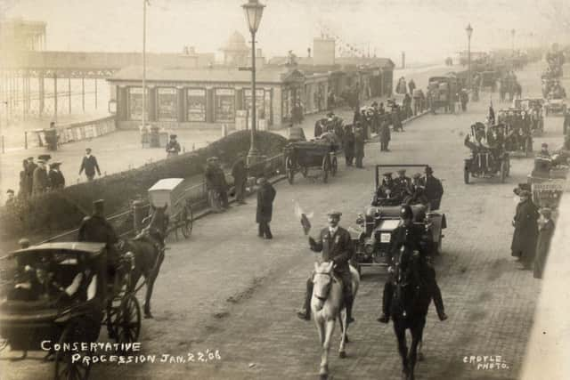
Conservative Procession Jan 22 06.
This 110 year-old postcard by St. Leonards Photographer Croyle shows the ‘victory parade’ following the parliamentary elections of 15th January 1906 where, as always, Hastings bucked the national trend and returned a Tory MP; Harvey Du Cros, millionaire Irish owner of Dunlop who held a near-monopoly of the car tyre trade. The Conservative government had been swept aside by a landslide Liberal vote, but the Tories took this seat from the Liberals. St.Leonards Pier and Royal Victoria Buildings can be seen on the left and it will be more than a year before the tramway would reach this part of the borough.
106 Marina.
Harvey Du Cros’ St Leonards residence at 106 Marina decked out for the 1906 elections
Arch, Collier & Pier.
From an albumen print by an unknown photographer it shows how close the edge of promenade was to the houses. St.Leonards Arch can be seen on the left and a collier (coal boat) unloading on the beach opposite the bottom of London Road. The ‘pulling-off anchors’ used to haul the boats back out to sea at high tide can still be seen embedded in the beach when there are very low tides. To the right can be seen Hastings Pier with some sort of ramp reaching down to the beach below the end pavilion.
155. The Lido Bathing Beach, St.Leonards.
Advertisement
Hide AdAdvertisement
Hide AdPosted in 1934 this image illustrates the clutter (The Royal Victoria Buildings etc.) in front of the Royal Victoria Hotel (on the left). After years of wartime neglect these buildings were swept away in 1946 and the end of the terrace on the right was demolished in the late 1930’s to make way for ‘Marine Court’.
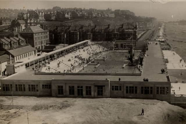
Europe’s Finest Bathing Pool, Hastings.
Pictured not long after it opened in 1933 The Bathing Pool dominated West St.Leonards. The Pickfords warehouse on the left was originally built as a Terminus Hotel for the London Brighton and South Coast Railway’s station at West Marina in the 1840’s but before it could be completed the railway tunnels to Warrior Square and onward to Hastings had been dug and terminus moved to the centre of Hastings so the building was finished as a furniture warehouse and. now, as luxury apartments is nearer its original purpose. Parts of the Bathing Pool Terrace on the right still exist today.,
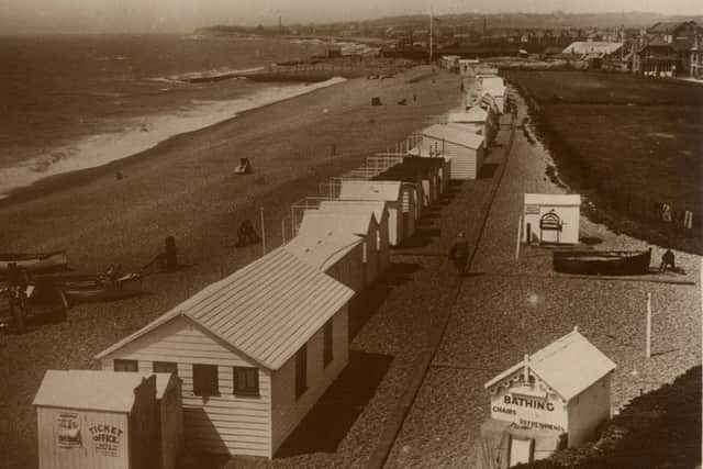
Foreshore and Bathing Station, West St.Leonards.
Posted in 1929 this view shows the area later occupied by the Bathing Pool, and following demolition, looks very similar today. The local Fire Brigade building can be seen in the top right corner.
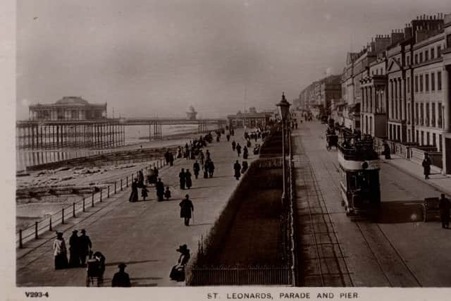
St Leonards, Parade and Pier.
This postcard published by the Rapid Photo Co of East London shows the shoreward end of the 960ft long St.Leonards Pier with its magnificent pavilion. Opened by Lady Brassey in 1891 it was severely damaged in World War Two and never re-opened, it was finally demolished in the early 1950s. When trams started running along the seafront in 1907 the Dolter Stud system was used and the studs can be seen between the tram rails, This system was not successful and in 1914, a petrol-electric solution was employed with on-board generators providing power until finally, in 1921 overhead wiring was installed. The magnificent Burton terrace with its Palladian fronts was demolished at the end of the 1930’s to make way for Marine Court.
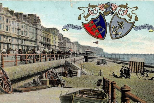
Eversfield Place, St.Leonards on sea.
Advertisement
Hide AdAdvertisement
Hide AdThis hand-tinted postcard from the early part of the last century is sporting the crest of Hastings with the fouled anchor of St.Leonards and shows what is now the western end of Bottle Alley. The large wheels are spares for the bathing machines and a boat from the Hastings & St.Leonards Angling Association is drawn up on the access ramp. In the far distance, beyond Hastings Pier, the chimney of the corporation’s dust destructor can be seen.
St.Leonard Arch.
In this image from the 1880’s the St.Leonards Arch can be seen on the left and the buildings in the centre were drastically modified by the Luftwaffe but the scene is instantly recognisable today.
Don’t miss out on all the latest breaking news where you live.
Here are four ways you can be sure you’ll be amongst the first to know what’s going on.
Advertisement
Hide AdAdvertisement
Hide Ad1 Make our website your homepage at www.hastingsobserver.co.uk
2 Like our Facebook page at www.facebook.com/hastingsobserver
3 Follow us on Twitter @HastingsObs
4 Register with us by clicking on ‘sign in’ (top right corner). You can then receive our daily newsletter AND add your point of view to stories that you read here.
And do share with your family and friends - so they don’t miss out!
The Hastings Observer - always the first with your local news.
Be part of it.